![]()
links
a random selection of newspaper articles written about bowie, one as far back as 1882.bowie unified school district #14
the schools operate classes for pre-kindergarten through grade 12, with an elementary school, a middle school, and a high school.
the school district was formed in 1883, when the cochise county board of supervisors autorized the school trustees of teviston "to form a school district at teviston, to include all children of school age within five (5) miles of teviston, cochise county, a.t." (note: the name of the town was changed to bowie in 1911.) in 1885, james h. tevis, the founder of teviston, later bowie, gave ground for a school site and the southern pacific donated a portable building for the classrooms.
since that time bowie's pride in their public schools is evident. it has the usual alumni array of doctors, lawyers, architects, judges, and many others from nearly all walks of the business and professional communities. bowie graduates are in the public sector as well as the private sector of the state, nation, and internationally. most graduating students plan to attend post-high school programs.fort bowie national historic site
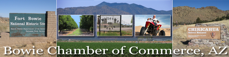
the most direct and shortest route to fort bowie national historic site is from bowie. travel south for 13 miles on apache pass road, which is paved to 1/2 mile of the trailhead and parking lot.
originally established in 1862, 2012 marks the 150th anniversary of the establishment of fort bowie, a military outpost that was built during the decades-long conflict between the us military and the chiricahua apaches.
fort bowie will have ranger led tours, during march 2013. also available are vans to transport participants to the visitor center.
"cochise county trail guide; our guide to some of the highlights of the arizona county that still puts the �old� in old west" by charlie vascellaro
"arizona centennial; during its centennial year, there�s no better place to discover the copper state�s cowboy and indian past than cochise county" by charlie vascellarochiricahua national monument can be reached from bowie by traveling south on apache pass road, pass the fort bowie parking lot, through scenic apache pass to highway 186; 21 miles as shown on the maps. apache pass road is now paved almost the entire 13 miles to the fort bowie parking lot at the trailhead.
hot well dunes recreation area is just 19 miles from bowie.the 11,700-acre dos cabezas mountains wilderness is seven miles south of bowie. travel south along apache pass road then west on the dirt road leading to happy camp canyon.
locally known as the masonic picnic ground and the lions picnic ground.
southeast arizona economic development group's purpose is to responsibly develop and expand the economy of cochise county and to work with existing and prospective business-owners and other stakeholders.southeastern az rural chamber alliance"rural chamber alliance formed to meet rural needs".
the alliance was formed to meet the unique needs of local area businesses. by forming an alliance, rural businesses will be better equipped to deal with the unique challenges facing them.